After going to Baker Lake for several years for our February outing, we tried a new location for 1998: Ancient Lakes. This became a standard Winter-Spring destination (including the next coulee over, Dusty Lake) for the troop until its demise.
The Ancient Lakes are a number of small lakes at the head of a coulee draining into the Columbia. The lakes were formed when during the last ice age, the waters of huge lakes dammed by ice from the continental ice sheet were unleased onto the Columbia Plateau when the ice dams repeatedly broke. These tremendous floods poured over the walls at the head of the coulee where a huge twin waterfall dug out the lakes at the base of the cliffs.
Even today you can still see the high water mark left by those flood waters long ago. It is apparent that the whole coulee was filled by water at one time. It must have been an awesome sight, had anyone been there to see it. It is still beautiful today, as a small waterfall flows into the upper lake.
For a longer narrative about this trip: [CLICK HERE]
The WTA page for the Ancient Lakes Trail: [Click Here]
Adults on this trip:
Bill Mooseker, Bill Peckinpaugh, Steve Goodwin, Greg Phillips, Gary Shively, Carl Douglass (sr)
Scouts on this trip:
Carl Douglass, Rob Douglass, Peter Goodwin, David Hoff, Mark McAfee, Kyle Meissner,
Andrew Mooseker, Austin Peckinpaugh, Brian Sisk, Adam Phillips, Roger Shively, Jason Smith,
Ben Spencer, Danny Stallings, Shelby Stong, Chip Walker, Eric Walkingshaw, Jon Younger
The descriptions under the photo thumbnails in the album sometimes contain links to maps or additional information. These are identified by "Blue” text for links. Some links may go to Google Maps to show where certain photos in the album were taken or to locate features shown in the photos. For Google Map links, click on the link, close the sidebar, and choose satellite view. Basically, you can then zoom in and out using the mouse wheel or drag the map by clicking and holding.
Troop 24 "The High Adventure Troop" Backpacking Trip
-Cascade Bill Mooseker
Date(s): February 1998. Album by Cascade Bill. 1 - 23 of 23 Total. 1619 Visits.
enlarge 354KB, 1024x702 1 pics 1
To enlarge photos, click on the thumbnail - the photo will pop up enlarged to 1024 pixels max (height or width). To view at Original size, just click on the enlarged photo, which will show the photo enlarged to fit the screen. Click on the screen to enlarge that portion of the photo at original resolution. Click again to reduce.
If you want to save photos to your computer, click the box under the thumbnails of all the photos you want to download. Then click the "Download" button at the top of the album. Pick the size you'd like to download (Original is best)and the photos will be downloaded as a zip file to the folder of your choice.
enlarge 171KB, 1152x719 2 98-297-020a Trailhead is located HERE
At the trailhead for Ancient Lakes (L to R):
Bill Peckinpaugh, Andrew Mooseker, Peter Goodwin, Austin Peckinpaugh (kneeling), David Hoff, Danny Stallings, Eric Walkingshaw, Carl Douglass (SR), Ben Spencer (?), Adam Phillips, Greg Phillips, Jason Smith, Chip Walker, Jon Younger, Brian Sisk, Mark McAfee, Steve Goodwin, Kyle Meissner, Gary Shively, Shelby Stong (?), Roger Shively, Carl Douglass (jr), Rob Douglass
enlarge 216KB, 1024x657 3 98-297-021a Heading out along the old road
enlarge 200KB, 1024x662 4 98-297-022 Further along - note the seasonal waterfall at the left.
enlarge 322KB, 1152x689 5 98-297-023
The first lake comes into view - Steve Goodwin, Greg Phillips, Carl Douglass Sr, Carl Douglass Jr
enlarge 255KB, 1024x661 6 98-297-024 Almost there - we camped on an isthmus seen above between two of the lakes.
enlarge 265KB, 1024x667 7 98-297-025 Scouts are far ahead
enlarge 262KB, 713x1024 8 98-297-029 The trail dips down and then back up onto the isthmus.
enlarge 236KB, 1024x668 9 98-297-028
From this photo, it appears that the water level is much higher than shown on Google Maps, which shows two separate lakes not one as appears here. The basalt cliffs dominate above.
enlarge 252KB, 1024x642 10 98-297-030
We took a hike to the cliffs above our camp - if you enlarge the photo, you can see our tents along the isthmus below.
The terrain here is open with not much vegetation besides grass and an occasional tumbleweed. The only drawback to camping is that there is no firewood available. We carried a bag of charcoal in for cooking our meals on a dutch oven.
enlarge 246KB, 1024x663 11 98-297-026
From the clifftop you can imagine the tremendous waterfall that gouged out the land to form the lakes.
Click HERE to read an article that explains the process that created this coulee and its lakes.
enlarge 183KB, 1024x643 12 98-297-031
The Columbia River lies in the valley beyond - In the Google Map of the area, CLICK HERE, the two lakes left of center are dry.
enlarge 258KB, 738x1024 13 98-297-027 Looking across the cliff over the two easternmost lakes.
enlarge 279KB, 1152x687 14 98-297-032 Looking east from the top of the bluff - Peter, Andrew, and Steve.
enlarge 346KB, 1024x676 15 98-297-034
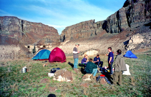
Day 2 - half the group were packing up and hiking out. As this was the long President's Day weekend, the Shepherds Patrol was spending another night. Visible in the picture are (L to R) Gary Shively, ?, ?, ?, Bill Peckinpaugh, Steve Goodwin, and Greg Phillips.
One thing we discovered on this outing was that tumbleweeds are not good for replacing firewood. This was much to the chagrin of the Doberman Patrol, who had bragged about how good their steak and baked potato dinner was going to be. Unfortunately, there was no firewood, so they had to piggyback on what was left of our charcoal to try to cook their dinner - the result was raw potatoes and char-raw steak. It was so bad, the next morning, when some hikers came by, their dog refused to eat a piece of steak that was on the ground.
enlarge 270KB, 1024x675 16 98-297-035 It was a much nicer day than the day we hiked in.
enlarge 299KB, 1024x661 17 98-297-036
Shepherds enjoying a warm February afternoon in camp -Chip Walker, Kyle Meissner, Peter Goodwin, Danny Stallings, Andrew Mooseker, and Steve Goodwin.
enlarge 254KB, 1024x671 18 98-297-037
In the afternoon, we hiked up the bluff above our camp. Here Kyle, Danny, and Andrew are trying their hand at fishing in Judith Pool located HERE.
enlarge 239KB, 1024x657 19 98-297-038 Looking up the coulee south of Judith Pool.
enlarge 202KB, 1024x671 20 98-297-039 Looking west towards the Columbia from Judith Pool.
enlarge 318KB, 700x1024 21 98-297-040
The waterfall at Ancient Lake #1. Although we tried some fishing, only Brian had any luck. This photo was taken as we packing up to head out.
enlarge 238KB, 1024x655 22 98-297-041
Leaving Ancient Lakes - a much brighter day than when we hiked in.
enlarge 222KB, 1024x654 23 98-298-001
Just about ready to head out - Steve, Danny, Kyle, Andrew, Peter, and Chip. You can see some fishermen who have hiked in at the lake on the left.