
1
8/26 - Double rainbow, Grimes County, TX
| 
2
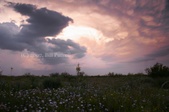
5/30 - Wildflowers, supercell. Callahan County, TX.
| 
3
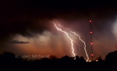
5/31 - Lightning display, Midland, TX.
| 
4
5/31 - Lightning display, Midland, TX.
|

5
5/31 - Lightning display, Midland, TX. Note illumination of precipitation fallstreaks being blown from left to right (northward).
| 
6
5/31 - Lightning display, Midland, TX.
| 
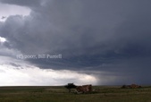
7
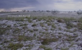
6/1 - Developing supercell, Seminole, TX.
| 
8
6/1 - Developing supercell, Seminole, TX.
|

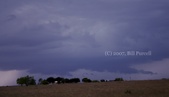
9
6/1 Supercell, developing tornado. SE Gaines County, TX.
| 
10
6/1 - Wall cloud, brief dust-tube tornado - SE Gaines County, TX.
| 
11
6/1 - Re-organizing mesocyclone after outflow-dominant phase.
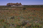
| 
12
6/1 - Desert wildflowers, massive A-bomb supercell at sunset. Andrews County, TX.
|

13
6/1 - Supercell at sunset. Andrews County, TX.
| 
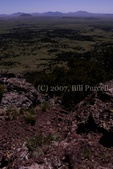
14
6/3 - Supercell (wall cloud, tail cloud). Midland, TX.
| 
15
6/3 - Mesocyclone with tilted, multi-tiered wall cloud and wild "blue streak" south of Midland.
| 
16
6/3 - Intense rotation within sloped updraft as the storm bears down on Midkiff.
|

17
6/3 - Apparent anti-cyclonic eddy (tornado?) on the extremity of the RFD, just west of Midkiff.
| 
18
6/3 - Ominous wall cloud looming above wheat field, pumpjack. Black-and-blue "whale's mouth" in the rear flank undercut by outflow. Midkiff, TX.
| 
19
6/3 - Hailfall, hail fog. About 10 SE Midland.
| 
20
6/3 - Disc-shaped hailstones to about 1" diameter, with concentric banding of clear and white ice. Stones were likely spinning vertically as they were tossed up and down through different temperature strata.
|

21
6/3 - Drifting hail fog.
| 
22
6/4 - Gaillardias, Tahoka daisies, groundsel - Palo Duro S.P.
| 
23
6/4 - Prickly pear, the "Lighthouse" formation - Palo Duro S.P.
| 
24
6/5 - Developing high-based storm. Union County, NM.
|

25
6/5 - Updraft wraps up tightly into donut-shaped supercell. NW of Clayton, NM.
| 
26
6/5 - Rain falling through mesocyclone.
| 
27
6/5 - Rotation weakens as storm to the west intensifies and precipitation interacts with initial storm.
| 
28
6/5 - Second storm intensifies further, begins to show rotation.
|

29
6/5 - Second storm wraps up broad, elongated mesocyclone.
| 
30
6/5 - Second supercell before it begins to weaken.
| 
31
6/5 - Disorganized convection, Dallam County, TX.
| 
32
6/7 - Monument Rocks, KS.
|

33
6/7 - Natural arch, Monument Rocks.
| 
34
6/7 - Cliff swallows, mud nests in the arch - Monument Rocks.
| 
35
6/7 - Gaillardias at Monument Rocks.
| 
36
6/7 - Swallow hovering upside-down, presumably feeding its young. Monument Rocks.
|
37
6/7 - Gaillardias, Monument Rocks.
| 
38
6/8 - Wildflowers, red sandstone. Union County, NM, Hwy. 456.
| 
39
6/8 - View from the rim of Mt. Capulin, NM.
| 
40
6/8 - Mountain lupine, Capulin volcano.
|

41
6/9 - Wildflowers, storm anvil - Melrose, NM.
| |
